We did it! We survived the Top of the World Highway. Up through Chicken, Alaska, on the Taylor Highway section, then on to Dawson City, Yukon, on the Top of the World Highway, and then into Takhini Hot Springs just north of Whitehorse, Yukon, on the Klondike Highway. Please note, the word "highway" is used VERY loosely. The Top of the World Highway was mostly dirt and gravel with just a few areas of actual pavement.
 |
| Taylor Highway Sign |
 |
| View Along the Taylor Highway |
 |
| Another View From the Road |
Chicken is not far mileage-wise from Tok, only about 77 miles. However, it took about two hours to get there. The Taylor Highway was paved with various road patches until the last two miles before we reached Chicken. Then it was pot-hole city, hang on to your dentures, hang on Sloopy until we reached Chicken Gold Camp. Again we had gray skies with a little spit on the windshield occasionally. Chicken got its name because ptarmigans were plentiful when early settlers arrived. A ptarmigan is a chicken-like bird. It seems there was a problem spelling ptarmigan so the place became known as Chicken. There isn't much to the town nowadays when gold mining was at its peak. Mining is still very evident in places, but I think it is mainly becoming a tourist stop-over along the highway.
 |
| "Downtown" Chicken |
 |
| Public Restrooms in Chicken |
Chicken Gold Camp was a nice place. It had quite a few level back-in campsites with firepits and electrical service, plus a very nice gift shop and cafe. It is the home of Chickenstock, featuring bluegrass music and held the second weekend of June. It also is the new home of the Pedro Dredge and we were able to get a tour of the now-retired gold dredge. The tour was interesting seeing the inner-workings of a gold dredge and learning the history of it. (More on dredging later)
 |
| Sculpture @ Chicken Gold Camp |
 |
| Chickenstock Stage |
We left Chicken the next morning under more gloomy and dripping skies. Needless to say, that made the road extremely muddy in several places. Mud that plastered itself to the truck and See-More. The border crossing back into Canada was uneventful. The road was in better shape -- more gravel, less mud, but visibility dropped. We were lucky at times if we could see 100 feet in front of us. Not much of a view when all you can see is fog/cloud cover. It was that way from the border until just before the ferry crossing at Dawson. Yuck.
 |
| Active Mining Operation |
 |
| Coming into Boundary area |
 |
| Cafe Boundary - Closed |
 |
| Border Crossing Peeking Out From Under the Clouds |
 |
| Top of the World Highway Sign |
 |
| Welcome to Dawson Sign - In the Dense Fog |
 |
| Free Ferry Across the Yukon River |
 |
| Tourist Trap - I mean, Paddle Wheeler on the River |
 |
| A Very Muddy See-More |
Dawson City was a neat little town with all of their restored buildings. Unfortunately, I do not have any pics of downtown Dawson because 1) it rained a lot; and 2) I was sick and was not up to much sightseeing. We have all been battling colds and it got me good while in Dawson. One day all I wanted to do was sleep but I did drag myself out of bed long enough to go visit the historic Dredge #4 up Bonanza Creek. I also drove up to the top of the Midnight Dome in between breaks in the rain. This was a great overlook of the surrounding areas.
 |
| From the Midnight Dome - Bonanza Creek |
 |
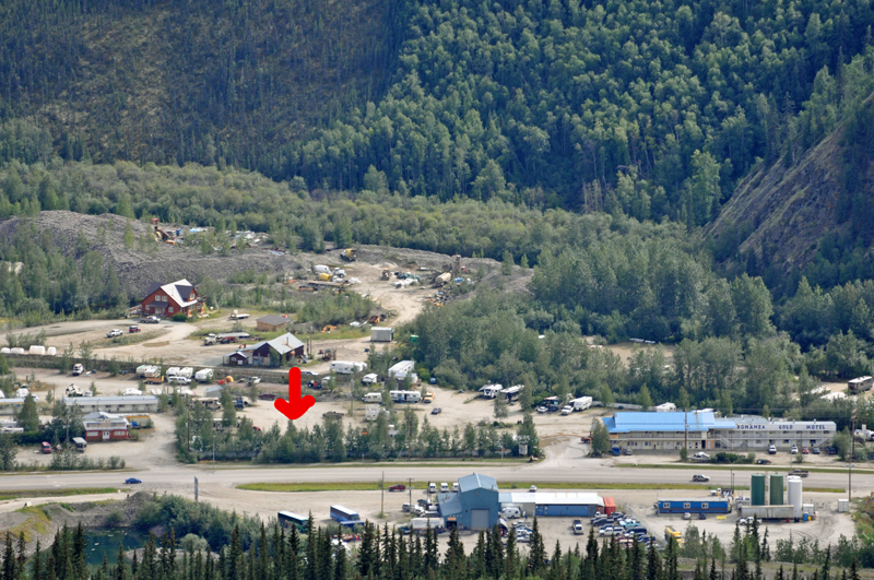
| Our Campsite Under the Red Arrow |
 |
| Downtown Dawson City from the Dome |
 |
| Flowers up on the Dome |
We stayed at Bonanza Gold RV park at the base of Bonanza Creek. Although the sites felt close together, we ended up not having neighbors on either side of us for the three nights we were there. Thank goodness the RV park had a vehicle wash! We had about an inch of mud on the truck's running boards not to mention the coating on See-More. It cost one loonie ($1 CDN) for three minutes of pressure washer time. I know we put in at least a dozen loonies trying to wash off as much muck and grime as we could.
 |
| A Clean See-More @ Dawson City |
It was on Bonanza Creek that gold was found and triggered the Klondike gold rush of 1898. Dredge No. 4, which is the largest wooden-hulled dredge in the world, is in the process of being restored.
Basically, here is how a dredge works:
A large gold dredge uses a mechanical method to excavate material (sand, gravel, dirt, etc.) using steel "buckets" on a circular, continuous "bucket line" at the front end of the dredge. The material is then sorted/sifted using water. On large gold dredges, the buckets dump the material into a steel rotating cylinder (a specific type of trommel called "the screen") that is sloped downward toward a rubber belt (the stacker) that carries away oversize material (rocks) and dumps the rocks behind the dredge. The cylinder has many holes in it to allow undersized material (including gold) to fall into a sluice box. The material that is washed or sorted away is called tailings. The rocks deposited behind the dredge (by the stacker) are called "tailing piles." The holes in the screen were intended to screen out rocks (e.g., 3/4 inch holes in the screen sent anything larger than 3/4 inch to the stacker). [source: Wikipedia]
 |
| Gold Dredge Diagram |
1. Gold Bearing Gravel
2. Bucket Excavator (Bucket line)
3. Revolving Screen (Trommel)
4. Gold Saving Sluice
5. Tailings Stacker
6. Dredge Pivot Point (Spud)
7. Master Control Room
8. Floating Barge
9. Self-Dug Dredge Pond
10. Tailings
The sluice box areas on the dredges were locked and only authorized people were allowed in to collect the gold flakes and small nuggets that were captured in the coconut matting. The mining season was about eight months long. Dredges are cool pieces of machinery.
 |
| Stacker on the Pedro Dredge in Chicken |
 |
| Front of the Pedro Dredge |
 |
| Rotating Screen - Pedro Dredge |
 |
| Sluice Boxes - Pedro Dredge |
 |
| 3 Cubic Feet Buckets - Pedro Dredge |
 |
| Old Bolts - Pedro Dredge |
 |
| Control Room - Pedro Dredge |
 |
| Map of Dredge Areas - Pedro Dredge |
 |
| Buried in the Gravel and Dug Up - Pedro Dredge |
 |
| Workbench - Pedro Dredge |
 |
| Control Room - Dredge No. 4 |
 |
| Bucket Line Area - Dredge No. 4 |
 |
| George in the Control Room - Dredge No. 4 |
 |
| Levers - Dredge No. 4 |
After leaving Dawson City, we heading down the Klondike Highway to Takhini Hot Springs. Again, I use the term "highway" loosely. Several sections were graveled and full of pot holes from the recent rains. Oh, it rained on us a little again this day. It was slow going in places and See-More picked up a little more mud. RV wash places are in high demand in these parts! But now we have a day of relaxation ahead.
Don't forget...you can click on any picture to enlarge them. ;-)


Just loved reading about the gold rushing and the dredging. Very interesting and what great pictures. Thank you for writing about this cause I have always wondered how they did it in such a large area. Living my dream to see Alaska through all of you!! Love you all and hope you are feeling better. <3
ReplyDeleteA trip of a lifetime for sure. Looking forward to seeing you in a couple weeks! Have a great finish to your Alaskan adventure.
ReplyDelete