Showing posts with label North Cascades. Show all posts

Sunday, July 6, 2014

Twisp Fly-in - Family Style

My sister, Karen, sent me a message last night. "Whatcha doing tomorrow?", she asked. I replied that we were playing golf in the morning and then hanging out around the house in the afternoon. "Why?", I asked back.

While George and I were out on the golf course this morning, plans were firmed up with Jim, my brother-in-law, this morning for them to fly over for a short visit. Cool! My sis and BIL live southwest of Seattle and we are on the eastern slopes of the North Cascade mountains - a five hour car ride away but only a 45 minute flight.

Here they come!

Doing the Fly-By First

Aligned with the Runway

A safe and smooth landing behind them, time to taxi to the parking area.

We're over here!

One of my sister's friends, Becky, also came along for the flight. George and I took them into town and we had a late afternoon lunch at the Twisp River Pub. Luckily for them, they didn't have to ride into town in this "classic" courtesy car provided by the airport.


Ain't she a beauty? But a ride in this is better than no ride at all!

It was fun to visit for an hour or so before it was time to take them back to the airport. No TSA hassles, no parking fees, just a little old country airport.

George helped Jim push the airplane out onto the taxiway and then Jim started his pre-flight checklist. I have flown with Jim before and he is a very competent pilot. I am not afraid to fly with him at all!

Push, George, Push!

Checking for water in the fuel
We said our good-byes and the trio took off.

They're up!

Up!

And away!

Until next time!

Wednesday, July 24, 2013

More from the North Cascades

Dreams - Near Harts Pass, North Cascades, Washington

Southbound on the Pacific Crest Trail - North Cascades, Washington

Tuesday, July 23, 2013

TwoFer Tuesday - Sisters

Over the July 4th holiday, my sister and brother-in-law came for a visit to our home in Washington's Methow Valley. We made a picnic lunch and went to Harts Pass. It was a lovely day, perfect for a picnic. We ate near the Pacific Crest Trail not too far from the Canadian border.

Oh, if I were a bit younger or in better physical shape, I would love to hike part of the PCT. For now I will live vicariously through stories like Wild by Cheryl Strayed or Skywalker by Bill Walker.

Sisters on the Pacific Crest Trail

Friday, December 7, 2012

North Cascades

Here are a few more shots from the airplane from my recent trip to Minnesota.

Glacier Peak

Serrated Knife Edge Ridge

Mount Baker in the Distance

Thursday, August 23, 2012

Skywatch Friday - North Cascade Panorama

A panorama I put together of the view from Slate Peak. This one is definitely worth enlarging.

North Cascades Panorama


The great team at Skywatch Friday allows us to share our photos from around the world each week. Click on the banner below to see what others have posted.


Wednesday, August 22, 2012

Hart's Pass & Slate Peak

I took a trip up to Hart's Pass/Slate Peak near Mazama, Washington last Friday. This is the highest drivable road at almost 7,300 feet in Washington. Once you leave the paved road, it is a twelve mile journey to Hart's Pass. Twelve long and slow miles along what was once a narrow wagon trail leading up to the now abandoned gold mine.

Starting up the Road Looking Back Towards Mazama

One particular half-mile section of the road is called Dead Horse Point and with good reason! The road clings to the side of the mountain along a very narrow cliff area. Back in the day, wooden planks were stretched across this area. In the 1890's a string pack of horses was crossing and the one of the last horses panicked not wanting to cross. Since they were all tied together, the other horses lost their footing and the whole string went off the edge of the road and plummeted several hundred feet down to the bottom of Rattlesnake Creek.

For me, this was not picture-taking time. This was white knuckle time!! (Coming back down from Hart's Pass, I was on the outside edge looking almost straight down into the ravine. Talk about instant vertigo! If I would have seen this going up the mountain, I'm not sure I would have made it to the top.)

Once we cleared Dead Horse Point and I took a deep breath, the road continues climbing. As you get nearer to Hart's Pass, you drive through an area decimated by the 2003 Needles Fire.

Winding Through Dead Trees
Just before reaching Hart's Pass at 6,200 feet in elevation there is a turn off that takes you past Meadows Campground (still in the burn zone) out to a point where the road ends. From there you can see the Pacific Crest Trail. It made for a nice place to have a picnic lunch.

Pacific Crest Trail Section

After lunch, we continued on our way past Hart's Pass and up to Slate Peak where the road ends just below the lookout. The military gave Slate Peak it's flat top look. There used to be a small lookout house on top of the mountain but the Cold War of the 1950's and fear of Soviet attack was incentive enough for the government to blow off the top of the peak and build a radar station. The radar station is long gone and the replacement tower sits exactly at the same height as the original mountaintop.

Slate Peak Lookout - Elevation 7,488 Feet

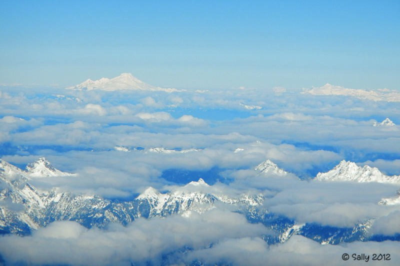
The sky was pretty clear, not too hazy. It is a short but strenuous (at least for me) half-mile hike from the parking area up to the top of the mountain.  Once up there, you have a 360 degree view of the surrounding North Cascades including Mount Baker to the west, the Pasayten wilderness and Canada eighteen miles to the north. It was simply spectacular!

Mount Baker Waaaay in the Back (52 miles away!)

The Old Mine Site - aka "The Glory Hole"

Hello, Canada!


Looking Down Towards the Parking Area and Hart's Pass Beyond

All in all, it was a great trip up to this area, even with Dead Horse Point. Glad I finally made it up to Hart's Pass and Slate Peak.

Wednesday, August 8, 2012

Mountain Layers

Just after the sun goes behind the North Cascade mountains, a soft glow layers the distant hills.

Methow Valley Sunset Looking North From the Airport


Thursday, July 26, 2012

SkyWatch Friday - Peekaboo

Passing by Rainy Pass high up in the North Cascade mountains on a beautiful sunny morning, this was the view out of my windshield as I drove west on Highway 20.

This was a stop and get out of the car moment

Clouds are clearing somewhat

Each week, the team at SkyWatch Fridays links up people from all around the globe. Click on the banner below and see what others are sharing.


Saturday, July 21, 2012

Alpine Golf?

I don't know why but when I looked at this meadow not far from Washington Pass in the North Cascades, I thought of golf. A verdant fairway and putting green interspersed with many sand traps. I'm sure there were water hazards, too. Namely small streams and waterfalls from melting snow channeling down the steep slopes. Fore!

Alpine Golf Anyone?

Friday, July 20, 2012

Liberty Bell in the Morning

I will say it again and again -- I never get tired of the North Cascades Highway, especially in the morning hours. Simply spectacular on a clear day.

Liberty Bell

Related Posts Plugin for WordPress, Blogger...